On the occasion of our trip to Albania to descent canyons, we made a very unproductive stop in the Julian Alps of Slovenia, near the border of this country with Italy and also with Austria, a point of the country that concentrates almost all the published declines that we can find in this beautiful Central European country.
Of all the days we have spent there, we have been able to make a few descents due to the rainy season that preceded our arrival and which has lasted for much of our stay in the country, which it has caused most of the descents to be overloaded with water.
However, as this website aims to be informative, here we share the information gathered before and during our stay in order to make it easier for future canyonists to visit the country.
A CANYONING GUIDE BOOK OF SLOVENIA
It has been absolutely impossible for us to find any store, bookstore or canyon company that has the old canyon guide of Slovenia, published, if we remember correctly, a distant 2004, in fact, the most common comment has been as long as such a guide does not exist, and in fact we believe that we have come to understand why we are no longer interested in editing a new guide, but in simply re-editing the old one.

Canyoning regulations in Triglav National Park
During our stay, we found that the little information we had about the ravines of Slovenia, located for the most part in the Triglav National Park, was incomplete in the most important aspect that must be taken into account in the time to do activities in any nature park, regulations.
Below is the text that you can find in the FAQ’s (frequently asked questions) on the park’s website and which refers to the canyoning regulations in this park in Slovenia.
Canyoning is allowed at below specified times and watercourses subject to the prior acquisition of a consent issued by the Triglav National Park Public Institute.
Fratarica
Access is along the existing marked path to the Parabola Waterfall and then further down an unmarked path to the Fratarica riverbed. The entry point is at approx. 820 m a.s.l. The exit point is at the confluence of the Fratarica and Koritnica rivers. Night canyoning is prohibited. Canyoning is allowed from 15 March to 31 October.
Predelica
Access is along the existing marked path that forks off the Predel – Bovec road at the bridge over the Mangartski potok brook to the Predelica river bed. One entry point is at the river pool called the Emerald Eye (“Smaragdno oko”), at an altitude of approx. 1050m, and the other (entry-exit point) is located at the confluence with the Mangartski potok at about 900m a.s.l. The exit point is located at the bridge over the Predelica at Log pod Mangartom.
Night canyoning is prohibited.
Activities in the upper Predelica are allowed from 15 March to 31 October, while the following regime applies to the lower Predelica:
1 April – 31 May, until 5 p.m.
1 June – 31 August, until 6 p.m.
1 September – 15 October, until 5 p.m.
Jerečica
Access is along the dirt road from the chapel at Podjelje to the river bed, or along a forest road to the sand pit at Jereka. One entry point is at an altitude of approx. 870m. The other entry-exit point at approx. 715m a.s.l, where the dirt road crosses the watercourse, and the final exit point at the sand pit at Jereka at an altitude of approx. 660m are both located outside the TNP area. Night canyoning is prohibited. Canyoning activities may be carried out from 15 March to 31 October.
Upon being issued a canyoning permit, the canyoning provider (guide) will recieve, to the e-mail address stated in the application, the user name and password to access the online application through which it can notify the Triglav National Park Institute of the time and place of canyoning, and the number of participants.
Canyoning in Slovenia outside Triglav National Park
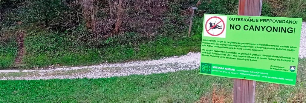
It may seem that with the regulations of the park extending its territories with enclaves that seem well made for the ravines that were outside its limits, and also with the specific ban for Kozjac the canyoning experience in Slovenia is in a nutshell, and surely it is reduced on the way! But outside the limits of the park, and in fact very close to these limits, there is still a stronghold of ravines with which we can enjoy bravely.
So, with the Fratarica, the Predelica and the Jerečica, the only three descents left within the reach of canyoners, outside the park we continue to find fun and suitable descents for a wide range of canyoning profiles, such as the Globoski Potok, the Susec for those looking for a rather playful ravine, or already outside the Soca Valley, the Veliki Pršjak and the unknown Kramarsca (2 × 15)
Map of Slovenian Canyons
We set off in the direction of Albania with this field map, with a total of 35 references to canyon descents that we have been able to add with days of research.
The color code is none other than red for the ravines inside the park and therefore are simply forbidden to descend or we know of any prohibition or restriction, and the color green, for those of us who have found that they are still allowed or are just outside the park limits. We appreciate that as we share this information, which has been so difficult for us to group together, please contact us if you know of any other regulations that may or may not affect some of the declines that we may have marked in red.
THE BEST TOPOGRAPHIC MAPS OF SLOVENIA
Unlike other Balkan countries, Slovenia, and especially its Julian Alps have a good offer in terms of topographic and quality maps with which to plan our routes, not only canyoning, but also hiking and any another mountain activity! So much so that we can even make our trip without spending a single euro on maps!
In many information offices we will be provided with topographic maps of the area free of charge, always at very different scales, most of them, but of very good quality and from the kartografija company, which also has a great offer of maps of Slovenia.
Where to buy cartographic and topographic maps of Slovenia?
In the capital Ljubiljana we were able to find maps of different publishing houses referring to many areas of Slovenia in the Mladinska Knjiga, a chain of which you will find several shops, but the one that has served us the best maps and where you will find a section with books sport in both Slovenian and English, you will find it at the address of the following link.
If the link does not work, try copying the address into your browser: https://goo.gl/maps/Sr4gjLBxm3ccXsD2A
In the “capital” of the Soca River Valley, Bovec, we were able to find a good variety of maps of the area, especially from the publishing houses Sidarta and the Italian Tobacco in a very good shop, located right in the large parking lot of the center. The store in question is Iglu Sport.
SLOVENIAN CANYON TOPOS
