Attracted by the description that the Canyonisme en Albanie guide makes of it, promising us a strong flow but the possibility of evaluating each obstacle before facing it, we have decided to visit the Erzen or Erzenit canyon, a laugh out loud. An adventure we will never forget, even more so for being the first canyon that forced us to stop and equip alternatives or use our ingenuity to safely overcome some violent water movements.
However, and as Guigui, the author of the guide, says, that the large amount of water that springs at the beginning of the canyon should not discourage you from exploring the bowels of this beautiful canyon, understanding that if, that if you have decided to follow the footsteps of this book to the last wild corner of the Balkans, you are experienced canyoneers and completely independent, because adventure is served and awaits us in every corner of this beautiful canyon.
ERZENIT CANYON GPS TRACK
ERZEN CANYON’S TOPO
You will find topographies in the book: Canyonisme en Albanie – Guillaume Coquin
ERZENIT CANYON DATA
Activity: Canyoning in Albania
Other toponyms: Erzen, Gryka e Skoranës
Starting point: Pëllumbas
Nearest town: Pëllumbas
Car combination: NO
Approach time: 1h
Descent time: 2h
Return time: 30′
Difficulty: v2a5I
Longest abseil: 12 mts.
Rope: 2×20
Cartography:
Soviet Military ~ 1980 – 1: 50,000 (Via Russian Topomaps APP)
Bibliography:
Canyonisme en Albanie – Guillaume Coquin
Albania Canyoning – Pascal Van Duin
Observations: Provide replacement material to install, just in case.

ACCES AND APPROACH TO ERZENIT CANYON IN ALBANIA
Leaving Tirana towards Elbasan, we only have to be at the exit in the direction of Pëllumbas, a beautiful mountain town. We can park at the very entrance of this one, to the right and in front of the first bar-restaurant there is a good car park where we spent the night and everything.
Be sure to visit the bar at the entrance, the couple who run it are very nice, and the girl has also learned Spanish by watching soap operas! (and it makes more golden potatoes than even our godmothers!)
From Pellumas we continue to the end of the main street where the path with red markings with a white line in the center leaves, the tourist path to Shpella e Pellumbasit, once we arrive at the cave we will spend a few minutes visiting it, and then begin a very steep descent pronounced, first along a very straight path, and then ending in a very vertical scree where we will have to be careful with the slips and not to throw stones at the companions we may have further down.
At the end of the scree, we will find the river, which we will cross without any problems and we will look for a small, very obvious path on the other bank, which goes back to the channel that comes from the dam that holds the Erzen upstream. We will follow the canal until we reach the dam, where we will find a very old wooden bridge that crosses the canal, and a tunnel that pours water into the river, this is the beginning of the descent.
THE ERZENIT CANYONING DESCENT
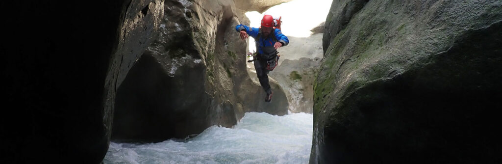
We begin the descent by abseiling from some iron bars towards the river bed, right where a large jet of water enters the canyon, coming from the dam we are close to.
The flow can impress, but good and knowing that almost all obstacles can be observed from outside the water to plan the management of water movements, you must not be overwhelmed by the amount of water that emanates from this hole
The first stretch, over this first bump, presents no more difficulties than some very small bumps and long stretches of swimming in water, generally calm.
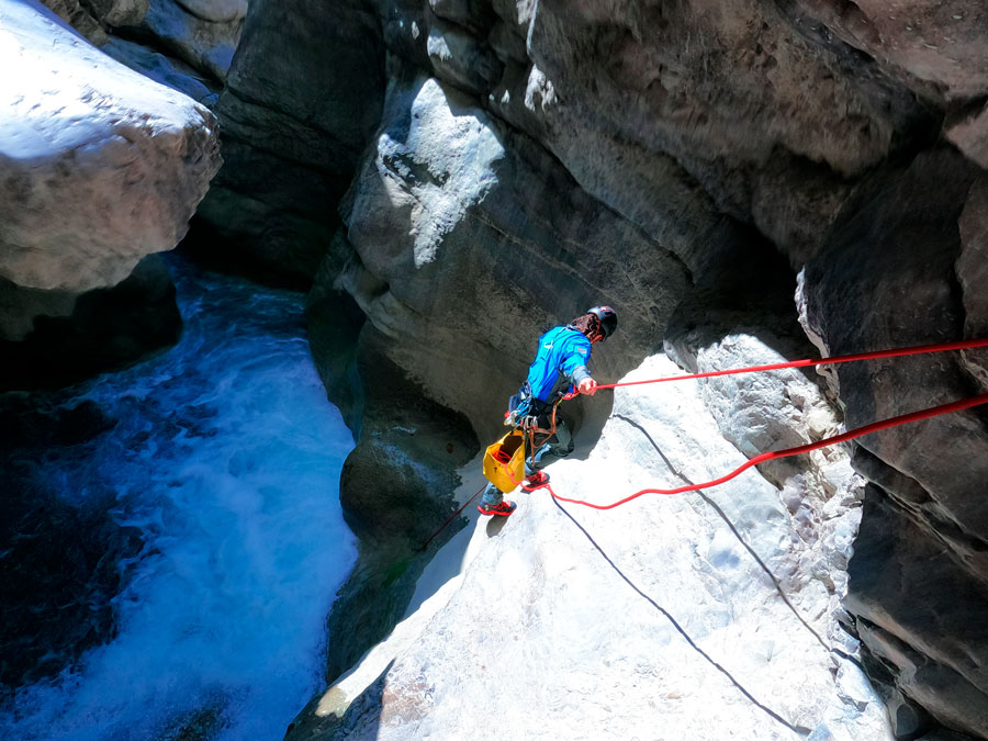
The first difficulty we will encounter will be an impressive waterfall of 12 meters through which all the water of the river falls, the topo of the guide indicates an installation in the center that we did not know how to find, and another on the left bank, which avoids the flow and allows us to rappel dry.
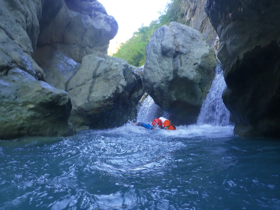
At the base of this rappel we will find ourselves in a large chamber with winds caused by the pressure of the water, from which we will leave through a small ridge where all the water also flows.
Further on, we will find a ridge equipped to the left, in a rocky tongue that exceeds the asset, although with high flow it can also be affected by water. We have serious doubts that this is the C8 that the review indicates.
We will continue down the canyon, in the most ambiguous section in our opinion than the review shows, our memory does not remember one of the two rappels on the left indicated, although if the continuation with a jump from the hydrographic right with some highlight more before arriving after a short walk to the first siphon, which in our case and due to the flow of the river, was not a siphon. With some other obstacle in the middle, we will reach what is indicated as the second siphon, and according to the review we should be close to the exit, nothing could be further from the truth, there is a final bottleneck missing, not without difficulties at take into account. We describe it as well as memory allows us:
Some more relief after the second siphon (which was also not due to the flow), and a small section of swimming lead us to a new obstacle, unequipped and which we do not recognize in the guide’s topo, with a large rocky ledge in the ‘left from where we can observe a good crossing to the right and a counter that makes it difficult for us to get out in the event of jumping into the pool of water.
Finally, we decided to equip a spit on the right to be able to rappel to a small “ledge” and from there jump off the water movements that are generated in the straits.
After briefly retracing the narrows where we will find a jump and some ledge, we will reach a new ledge that needs to be protected in some way, and in order not to waste any more time, we drop a large rock to the right and rappel a ramp with a lot of water, which it leaves us at a kind of bifurcation, with an impenetrable siphon on the left, and the continuation of the canyon on the right.
We will continue down the canyon until we find a spring, which smells strongly of sulphur.
Here we will look for the exit immediately to the left, in a scree next to the wall and on top of which we will find the path.
HOW TO RETURN FROM ERZEN CANYON
The return path begins in the form of scree with large boulders where you have to climb carefully, where we will find obvious traces of Albanian bathers.
If we keep going up we will end up finding a very obvious trail that we will follow without difficulty other than a point where we will come face to face with a rocky wall. At this point we will take the road, which is steeper and to the right, to continue climbing, little by little, until the village of Pëllumbas.